Landscape Management System (LMS)
Example Landscapes:
Bent Creek |
Bremerton |
Mid Forest Lodge |
San Carlos Apache |
Chornobyl Firest Risk Project
Yale University, New Haven, CT, Jan 31-Feb 2, 2007
- January 31st-Feb2nd 2007 - Chornoby Pilot Project - Initial work done a Yale University to investigate the potential fire risk of radioactive forests.
- July 26-27 2007 - International Meeting on "Reduction of Risk from Catastropic Wildfires in the Chornobyl Irradiated Forests, National Agricultural University of Ukraine, Kiev, Ukraine - Click link to open new browser or tab, then move down to July 25-28 for pictures from the conference.
- September 18th 2007 - Statement of the International Meeting on "Reducing Risk of Disaster from Catastrophic WIldfires in the Chornobyl Irradiated Forests" - Click link to open a new browser or tab to view PDF copy of statement.
Project Objective
The nuclear accident at the Chornobyl Nuclear Power Plant 80 miles north of Kiev, Ukraine contaminated a considerable portion of the forested landscape. The Exclusion Zone (18.5 mile radius, 504,200 acres) was established where people were evacuated and rehabilitation of the land has begun. Natural processes will likely rehabilitate the area without human intervention, however, considerable acres (about 1/2) are artificial Scotch pine plantations which are experiencing serious forest health problems from wildfire, windstorms, and insect pests. A considerable concern is the potential impact of smoke from the forests in the city of Kiev. The image below shows smoke from a fire traveling to Kiev. The contaminated forests are shown in the image as the pink areas to the north. A fire in the contaminated forests could easily create smoke that could impact Kiev. The current management approach involves little management of forest stands and to suppress all forest fires. This approach will likely lead to increased problems with insects and disease as fuel level increase, leading to larger and more severe fires. Prior to 1986 much of the area around Chornobyl was part of an actively managed forest which had been subdivided into divisions, quartiles, and stands. The two divisions used in this work are in the exclusion zone and total 33,3700 hectares. One division was composed of slightly older stands that were commonly of natural origin. The second division had a higher proportion of younger plantations and a significant amount of land in agriculture. This project is a pilot project to investigate the use of forest inventory information, growth and yield models, and fire risk models to evaluate the risk of wildfire in the area and to evaluate management approaches for the area that will reduce the risk of fire in the contaminated forests. |
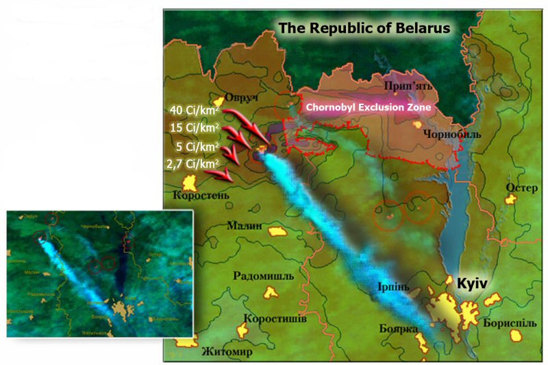 Figure 1. Example satellite image showing smoke from fire near exclusion zone traveling to city of Kiev. Image provided by the Ukrainian Land Resource Management Center (http://www.ulrmc.org.ua/). |
Participants
This project was made possible by a cooperative agreement between the Ukraine State Department - The Administration of the Exclusion Zone; The National Agricultural University of Ukraine; and Yale University - Global Institute of Sustainable Forestry. The GIS information for the Chornobyl forests was provided by Ms. Svitlana Bidna, Chief of GIS Department, Chornobyl Information Centre.
The following participated on the pilot project:
Name |
Title and Affiliation |
|
|---|---|---|
| Aaron Hohl | - |
Graduate Student, Yale University, New Haven, CT |
| James B. McCarter | - |
Research Scientist, University of Washington, Rural Technology Initiative, Seattle, WA |
| Andrew Nicolli | - |
Graduate Student, Yale University, New Haven, CT |
| Chadwick D. Oliver | - |
Pinchot Professor of Forestry & Environmental Studies and Director of Global Institute of Sustainable Forests, Yale University, New Haven, CT |
| Mykhaylo Petrenko | - |
Institute of Forestry and Landscape Architecture, National Agricultural University of Ukraine, Kiev, Ukraine |
| Sergiy Zibtsev | - |
Associate Professor (Forestry), Institute of Forestry and Landscape Architecture, National Agricultural University of Ukraine, Kiev, Ukraine |
 |
- | National Agriculture University of Ukraine |
Methods
The two divisions are comprised of nearly 8000 different stands. In those stands there are about 5700 inventory plots that contain tree information. The number of stands and inventory plots complicated the analysis given the short time available for the pilot project. To simplify the analysis a classification of inventory data was done to allow the creation of a subset of inventory plots that would represent the larger area. Figure 2 shows the original classification of the landscape using the Ukraine Ministry of Forestry land classification. Portfolios were created for all inventory plots in the analysis area. Because of the number of stands this resulted in 11 portfolios for the area. In addition two additional portfolios were created: ChornobylGroups which contains representative stands for each group resulting from the classification, and ChornobylDemo which contains a contiguous subset of the area that represents a wide variety of stand types in 280 stands. The inventory information was also used to examine the performance of the Lake States variant of the FVS growth model to determine the appropriateness of using this model for Ukrainian forests. A limitation of a simulation exercise for this area is the lack of comprehensive inventory information and growth models develop for the specific region. Our silviculture experience suggests that forests in this area behave similarly to forest near the Lake States portion of the United States. Because of this similar behavior we are starting with the Lake States variant of FVS as the growth model. The FVS growth model now includes the FFE extension that allows for forest simulations that incorporate fire risk calculations and the analysis of fire risk under alternative management approaches. FVS-FFE is being used as an initial fire risk assessment tool for this pilot project. We understand that considerable testing and calibration needs to be done to validate and possibly improve the fire risk estimates for Ukrainian forests. |
|
||||||||||||||||||||||||||||||||||||||||||||||||||||||
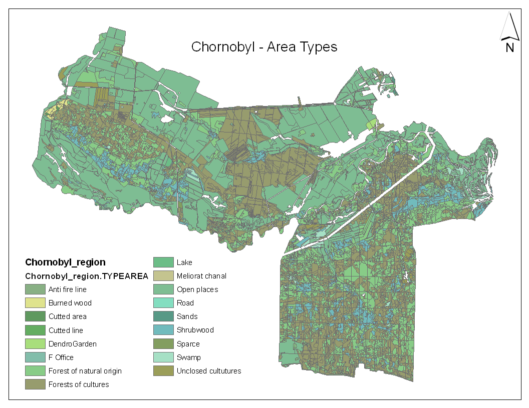
From examining inventory and stand level information it was determined that the landscape could be classified using a combination of stand age, site index, and forest cover type (conifer/hardwood). Examining age information showed logical breaks for stands less than 41 years and greater than 60 years. Site quality information was limited, but examination of the available information suggested four site classes: <16m, 16m, 19m, and >19m. The number of hectares in each group are presented in the table to the right.
The Ukraine Ministry of Forestry has developed a Fire Risk Classification system based on forest type, stand age, and soil type. A program was developed to assess the Ukraine Fire Risk using a combination of GIS and inventory information. The Ukraine Fire Risk Class was determined using the following:
|
|||||||||||||||||||||||||||||||||||||||||||||||||||||||
Results
The results of the stand classification are show in Figure 3. When comparing to Figure 1 note that only forested stand types are shown in the stand groups map. This classification provides a more sensitive classification within forest types, but may still be limited by the quality of inventory information. Examination of the inventory information shows that only 368 stands out of the 5700 inventory plots have more than one species. In addition the inventory is dominated by a single species, pine.
This is the condition of the inventory information, but may not reflect the actual situation on the ground since less common species may have been ignored during the inventory. A more comprehensive inventory needs to be conducted to get a better assessment of the forest conditions in the exclusion zone. |
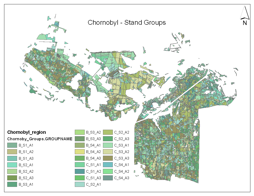 Figure 3. Location of stand groups in the Chornobyl area. Stand groups are named for a three part classification: B = broadleaf, C= conifer; Site class 1-4; Age class 1-3. |
|||||||||||||||||||||||||||||||||||
| The forest inventory information was classified using the Ukraine Fire Risk classification rules resulting in the map shown in Figure 4. This classification is based on stand age, soil moisture, and stand type. The map shows that the area is dominated by stands in the highest two risk classes (75% of the stands). | 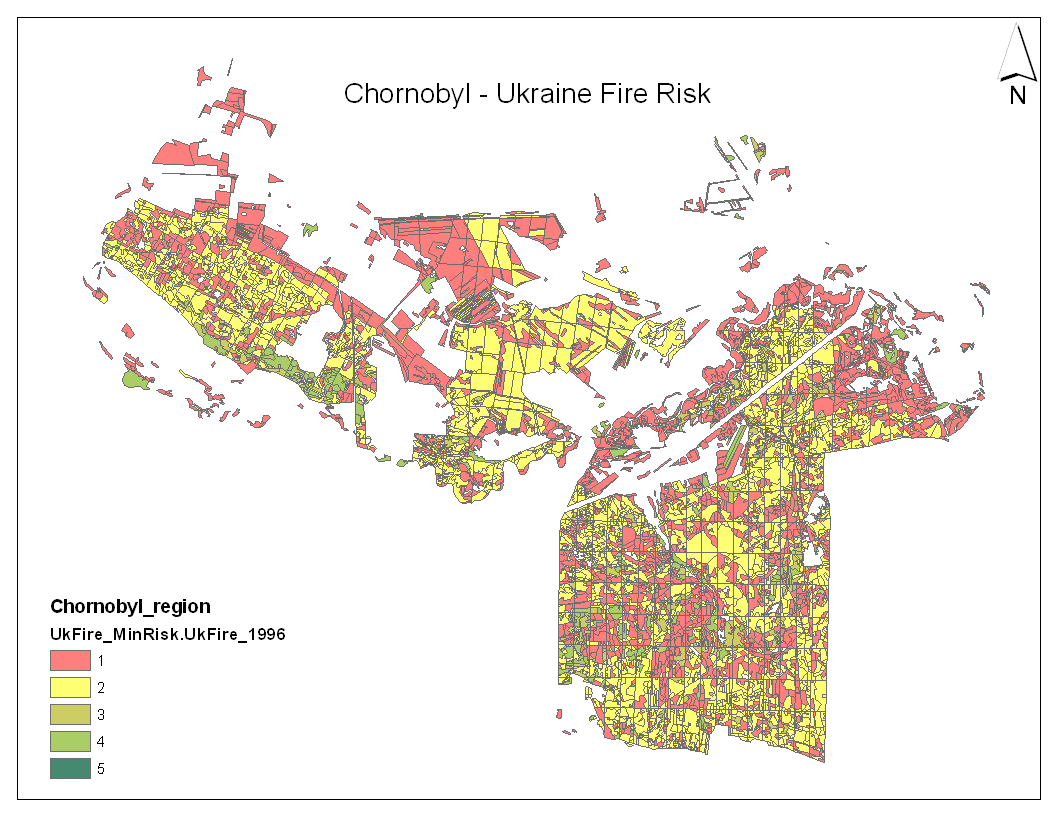 Figure 4. Ukraine fire risk class for 1996. |
|||||||||||||||||||||||||||||||||||
| Figure 5 shows the Ukraine Fire Risk classification displayed on digital orthography from Google Earth. | 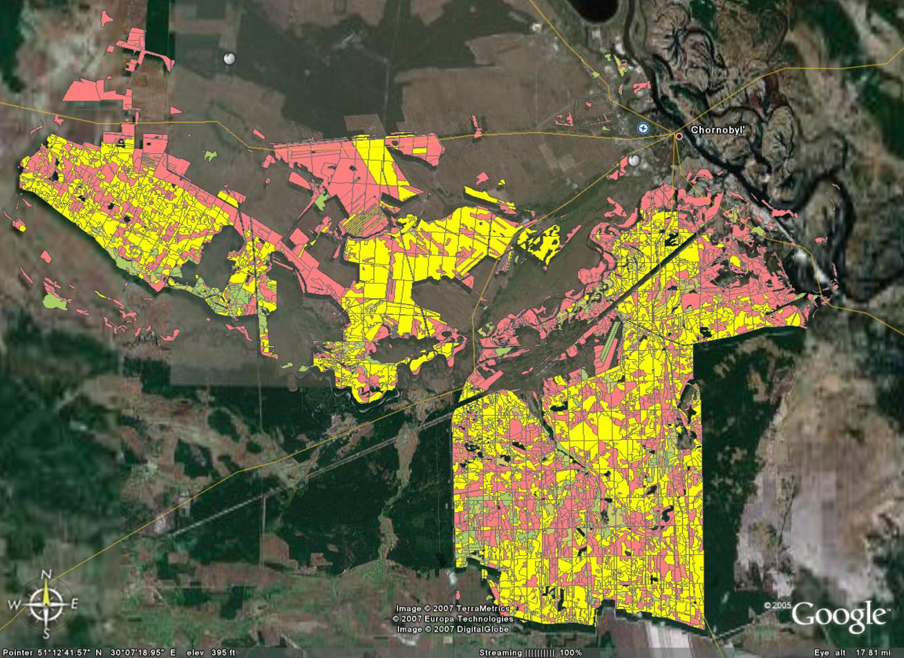 Figure 5. Ukraine Fire Risk in 1996 shown on top of orthography from Google Earth. |
|||||||||||||||||||||||||||||||||||
Using FVS to grow the stands into the future allows us to evaluate how the fire risk will change as the stands develop. Figure 6 shows the results of growing the stands forward 30 years with no management. The overall fire risk for the landscape has decreased with 36% of the area in risk class 1 in 1996 which was reduced to zero stands with risk class 1 in 2026.
This result is a misleading because of the dependence on stand age with no sensitivity to the relationship between stand condition and fire risk. Two stands comprised of the same species composition can have considerably different fire risks depending on the stand structure and the existence of ladder fuels which allow a ground fire to develop into a crown fire. |
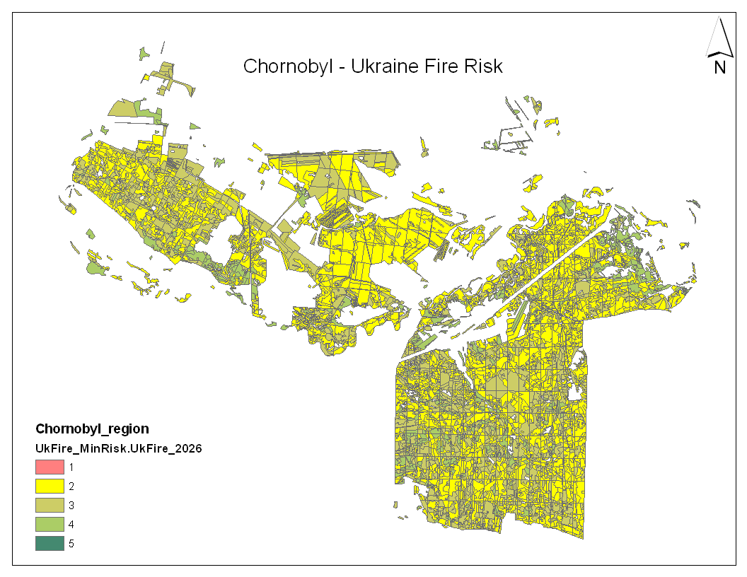 Figure 6. Ukraine fire risk classes in 2026 with no management. |
|||||||||||||||||||||||||||||||||||
| The Fire and Fuels Extension to the Forest Vegetation Simulator (FVS-FFE) was used to asses fire risk as it relates to stand structure and fuel loading. The exiting inventory information was simulated using the FVS growth model and risk variables were computed using FFE. Figure 6 shows the initial fire risk map in 1996. Using FFE produces a higher initial risk classification because of the predominance of dense stands with ladder fuels. The risk variable being used is Crowning Index: the wind speed necessary at 20 above ground necessary to sustain an active crown fire. Wind speeds below this number will result in a less damaging and easier to control ground fire. Wind speeds above the index will result in stand replacing fires. |  Figure 7. FVS-FFE Crowning Index in with no management, |
|||||||||||||||||||||||||||||||||||
| Simulating the growth of the forest 25 years forward produces the risk map shown in Figure 7. Using FFE suggests that the fire risk is not decreasing with time, but rather the risk is remaining high because of the slow growth of dense pine stands that dominate the landscape. This is in contrast to what is suggested using only the Ukraine Fire Risk classification. |  Figure 8. FVS-FFE Crowning Index in 2021 with no management. |
|||||||||||||||||||||||||||||||||||
A management strategy was developed that was designed to minimize fire risk on the landscape. The approach consisted of thinning all stands with high crowning index to 250 TPA from below in 1996. For stands where this treatment did not result in a reduced fire risk the stands were converted to hardwood/broadleaf stands in 1996. The stands in the group converted to hardwood stands were the older conifer stands. The results of this treatment are dramatic and shown in Figure 9. A limitation of this management approach is the need to treat almost every stand at the beginning of the management period. Given the capacity for management in the area and the risk of long term exposure to radiation in the area this approach is not practical. It is presented as an example of the potential that appropriate management can have on fire risk. |
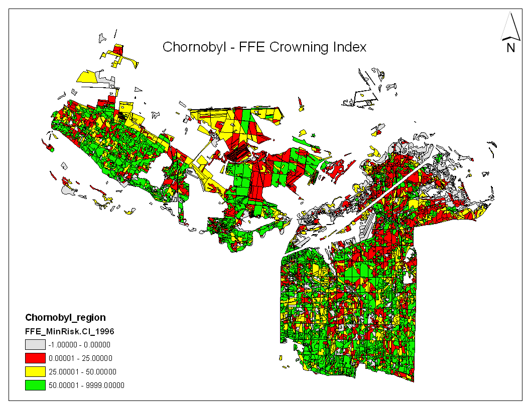 Figure 9. FVS-FFE Crowning Index in 1996 with risk minimization strategy. |
|||||||||||||||||||||||||||||||||||
| Simulation of the growth of the stands into the future shows that the fire risk remains similar after treatments (Figure 10). The fire risk is actually beginning to increase as the stands develop. Additional management should be considered to further reduce the fire risk in stands as they develop. |  Figure 10. FVS-FFE Crowning Index in 2021 with risk minimization strategy. |
|||||||||||||||||||||||||||||||||||
Next Steps
Funding is being sought to implement a more ambitious project that will include new improved forest inventory, calibration and/or development of fire risk and fuel models for the region, calibration of growth models for the region, and assessment of stand specific fire risk under alternative management strategies. The accomplishment of these tasks will lead to improved forest management along with the reduction of fire risk and therefore public safety in the region.
References
Amiro, B.D., A. Dvornik, and T. Zhuchenco. 1999. Fire and radioactivity in contaminated forests. In: Contaminated forests - Recent Developments in Risk Identification and Future Prospects, Proceedings of the NATO Advanced Research Workshop, Kiev, May 27-30, 1998. (Igor Lindov and WIlliam R. Shell, Editors). NATO Science Series 2: Environmental Security. Volume 58. Kluwer Academic Publishing Co. 311-324.
Dixon, G.E. 2002. Essential FVS: A User's Guide to the Forest Vegetation Simulator. U.S. Department of Agriculture, Forest Service, Forest Management Service Center. Internal Report. 209p.
McCarter, J.B., J.S. Wilson, P.J. Baker, J.L. Moffett, and C.D. Oliver. 1998. Landscape management through integration of existing tools and emerging technologies. Journal of Forestry. 96: 17-23.
Nepyivoda, Vasyl. 2005. Forestry in the Chornobyl Exclusion Zone: Wrestling with an Invisible Rival. Journal of Forestry. January/February 2005: 36-40.
Reinhardt, E.D., and N.L. Crookston. 2003. The Fire and Fuels Extension to the Forest Vegetation Simulator. U.S. Department of Agriculture, Forest Service, Rocky Mountain Research Station. General Technical Report. RMRS-GTR-116. 209p.
Wukoff, W.R., N.L. Crookston, and A.R. Stage. 1982. User's Guide to the Stand Prognosis Model. U.S. Department of Agriculture, Forest Service, Intermountain Forest and Range Experiment Station. General Technical Report. INT-133. 241 p.
May 30, 2011 4:57 AM
University of Washington |
Yale School of Forestry & |